DACF Home → Bureaus & Programs → Maine Natural Areas Program → Communities, Plants, and Animals → Natural Community Fact Sheets → Circumneutral Open Outcrop
Printer Friendly Fact Sheet - 1.1 MB pdf (Get a free copy of Adobe Acrobat Reader)
Circumneutral Open Outcrop
Scientific Name: Boreal Circumneutral Open Outcrop; State Rank: S2

- Community Description
- Soil and Site Characteristics
- Diagnostics
- Similar Types
- Conservation, Wildlife and Management Considerations
- Distribution
- Characteristic Plants
- Associated Rare Plants
- Associated Rare Animals
- Examples on Conservation Lands You Can Visit
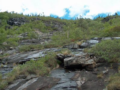
Community Description: These rock faces are sparsely vegetated with herbs and scattered meadowsweet and paper birch. Composition varies from site to site, but includes at least some species indicative of higher pH conditions, such as shrubby cinquefoil, ebony sedge, rock whitlow-cress, lance-leaved draba, Laurentide primrose, smooth woodsia, etc. Graminoids, including brownish sedge, and ferns, such as fragile fern and bulblet fern, may be locally abundant in moist pockets. Back to top.
Soil and Site Characteristics: This community occurs on low- to mid-elevation (<2700’) outcrops of limestone, dolomite, or other rock where weathering produces circumneutral to calcareous substrates. Sites are usually below the hill summit, on side slopes or cliffs rather than ridges. Slope varies, often with vertical faces and near horizontal shelves within the same area. Sites are typically dry but may have moist spots where seepage occurs. Back to top.
Diagnostics: A sparsely vegetated cliff/outcrop setting occurs below treeline, with herbs dominant; circumneutral indicator species are present. Back to top.
Similar Types: Acidic Cliff vegetation is also on bare rock faces, but on more acidic rock, and lacks any circumneutral indicator species. Low-elevation Balds likewise lack circumneutral indicators and typically occur on summits. Alpine Cliff vegetation can have some circumneutral indicators but is found at higher elevations (>3000'). Back to top.
Conservation, Wildlife and Management Considerations: Most known sites are relatively inaccessible and minimally affected by either forestry or recreational activities. Retaining a wooded buffer, where one would naturally occur, is important in maintaining the natural microclimate of the cliff and outcrop areas. Several known sites are within public lands or private conservation ownership. Back to top.
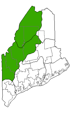
Distribution: Hills of northwestern and north-central Maine (mostly the New England - Adirondack Province, extending into the Laurentian Mixed Forest Province). Distribution outside of Maine is poorly understood. Landscape Pattern: Small Patch. Back to top.


Characteristic Plants: These plants are frequently found in this community type. Those with an asterisk are often diagnostic of this community.
- Sapling/shrub
- Meadowsweet
- Dwarf Shrub
- Shrubby cinquefoil
- Herb
- Brownish sedge
- Bulblet fern
- Fragile fern
- Fragrant woodfern
- Rusty cliff fern
- Bryoid
- Juniper hair-cap moss
- Ebony sedge
- Intermediate sedge
- Lance-leaved draba
- Northern woodsia
- Rock whitlow-grass
- Slender cliffbrake
- Smooth rockcress
- Smooth woodsia
- White bluegrass
There are no documented rare animals associated with this natural community.
Examples on Conservation Lands You Can Visit
| Example | County |
|---|---|
| Deboullie Ponds Public Lands | Aroostook Co. |
| Little Kineo Mountain Public Lands | Piscataquis Co. |
| Mount Kineo Public Lands | Piscataquis Co. |
| Trout Brook Mountain, Baxter State Park | Piscataquis Co. |