DACF Home → Bureaus & Programs → Maine Natural Areas Program → Communities, Plants, and Animals → Natural Community Fact Sheets → Low-elevation Bald
Printer Friendly Fact Sheet - 1.3 MB pdf (Get a free copy of Adobe Acrobat Reader)
Low-elevation Bald
Scientific Name: Three-toothed Cinquefoil - Blueberry Low Summit Bald; State Rank: S3

- Community Description
- Soil and Site Characteristics
- Diagnostics
- Similar Types
- Conservation, Wildlife and Management Considerations
- Distribution
- Characteristic Plants
- Associated Rare Plants
- Associated Rare Animals
- Examples on Conservation Lands You Can Visit
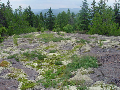
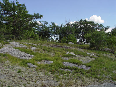
Community Description: Patches of blueberry, lichens, low herbs, and bare rock form a mosaic on these summits. Vegetation may be sparse, but usually forms 10-50% cover overall, often comprised of only a few species. Three-toothed cinquefoil may be locally abundant. A few coastal sites feature broom-crowberry, an uncommon species. Bryoid cover may be low or high and usually is dominated by lichens rather than bryophytes. This is the typical habitat of the rare smooth sandwort. Back to top.
Soil and Site Characteristics: Sites are on bald hilltops, mostly near the coast. Soils are patchy and usually consist of a thin, mostly organic layer, creating dry conditions. The substrate is acidic (pH 5.0-5.4). Elevations range from 600’-1500’. Back to top.

Diagnostics: Tree cover is virtually zero. Total vegetation cover is 10-50%, rarely more, and is dominated by a mixture of dwarf ericads, forbs, and graminoids, with three-toothed cinquefoil often locally dominant. Vegetation height rarely exceeds 0.3 m. Back to top.
Similar Types: Rocky Summit Heath is floristically similar and can occur with this type, but it has greater vegetation cover and height (patches > 0.5 m tall), and usually a sparse tree cover. Mid-elevation Balds are structurally similar but feature crowberry and bilberry as locally dominant dwarf shrubs; they generally occur at higher elevations and more inland locations than this type. Back to top.
Conservation, Wildlife and Management Considerations: Many sites have evidence of intense, vegetation-clearing fire (e.g., Acadia National Park fires of 1947), but it is not clear whether past fires were of natural or human origin. Moreover, at some sites historic fires may have pushed the vegetation beyond a ‘resilience threshold’, and there is so now little vegetation that it is unlikely that fire could return for several hundred years.
This type is well represented on public lands and private conservation lands. However, because this community type is usually associated with nice views, many sites have moderate to heavy hiker or ATV use. Because the vegetation is rather sparse, it is easy for visitors to wander off the trail, and off-trail traffic can seriously degrade the vegetation and has done so at several sites. Back to top.
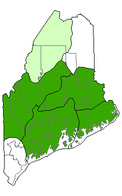
Distribution: Mid-coast Maine eastward, along the immediate coast to a short distance inland. Landscape Pattern: Small Patch. Back to top.


Characteristic Plants: These plants are frequently found in this community type. Those with an asterisk are often diagnostic of this community.
- Sapling/shrub
- Black chokeberry
- Dwarf Shrub
- Broom-crowberry*
- Lowbush blueberry*
- Herb
- Poverty oatgrass
- Three-toothed cinquefoil*
- Bryoid
- Awned hair-cap moss
- Reindeer lichen
There are no documented examples of rare animals associated with this natural community.
Examples on Conservation Lands You Can Visit
| Example | County |
|---|---|
| Black Mountain, Donnell Pond Public Lands | Hancock Co. |
| Mt Megunticook, Camden Hills State Park | Knox Co. |
| Pemetic Mountain, Acadia National Park | Hancock Co. |