DACF Home → Bureaus & Programs → Maine Natural Areas Program → Communities, Plants, and Animals → Natural Community Fact Sheets → Upper Floodplain Hardwood Forest
Printer Friendly Fact Sheet - 1.1 MB pdf (Get a free copy of Adobe Acrobat Reader)
Upper Floodplain Hardwood Forest
Scientific Name: Hardwood River Terrace Forest; State Rank: S3

- Community Description
- Soil and Site Characteristics
- Diagnostics
- Similar Types
- Conservation, Wildlife and Management Considerations
- Distribution
- Characteristic Plants
- Associated Rare Plants
- Associated Rare Animals
- Examples on Conservation Lands You Can Visit
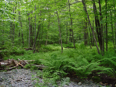
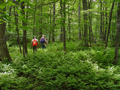
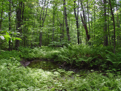
Community Description: An almost complete canopy is dominated by sugar maple, red oak, or yellow birch, with red maple and ash often common and basswood or black cherry occasional. The understory is open and shrubs are sparse. The lush carpet of herbs changes from spring ephemerals such as trout lily and bloodroot to variable cover of mixed graminoids and forbs in summer. Bryoid cover is minor. Back to top.
Soil and Site Characteristics: Sites occur on slightly elevated terraces flanking low-gradient rivers at elevations typically <1,000’. Flooding is occasional, sometimes less frequent than annually. These forests have lower frequency and duration of flooding than silver maple floodplain forests. Most known examples are along medium to larger rivers. Soils are fine sand or silt, usually with good drainage capacity and relatively high nutrient levels; pH is 5.0-6.2. Back to top.

Diagnostics: Sites occupy floodplain or river terrace settings with mineral soil. The canopy is dominated by sugar maple, red oak or yellow birch. Silver maple and red maple may be present. A dense herb layer that includes species not typical of wetlands (e.g. starflower, zig-zag goldenrod, big-leaved aster, silvery spleenwort). Sensitive fern is often present but not dominant. Spring ephemerals are often abundant. Back to top.
Similar Types: On large rivers, Silver Maple Floodplain Forests are often adjacent to these forests, occurring between them and the channel, and are dominated by silver maple. Red Maple Swamps have red maple dominant, and have soils that are flooded or saturated throughout the growing season. Northern Hardwoods Forests, Enriched Northern Hardwoods Forests, and Oak - Northern Hardwoods Forests can be similar in canopy composition but are not in the floodplain or terraces of a river. Hardwood Seepage Forests occur along small stream drainages, usually sloping with steeper gradients. Back to top.
Conservation, Wildlife and Management Considerations: Virtually all of these forests have been harvested, and many have been converted to agriculture. Non-native plant species such as Japanese knotweed and Asiatic bittersweet, which may displace those native to our area, represent a threat to the integrity of these forests and have degraded at least some Maine examples.
The northern waterthrush, barred owl, belted kingfisher, bank swallow, scarlet tanager, and green heron are associates of this community type. Wood turtles overwinter in river channels and forage in floodplain forests where they may feed on amphibian egg masses in vernal pools. The silver-haired bat often roosts in riparian habitats in trees with loose bark. Fairy shrimp may also occur in isolated vernal pools. Back to top.
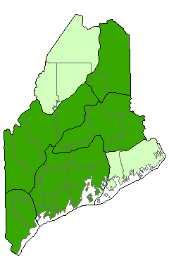
Distribution: Throughout Maine, New England, and New Brunswick. Landscape Pattern: Large Patch. Back to top.


Characteristic Plants: These plants are frequently found in this community type. Those with an asterisk are often diagnostic of this community.
- Canopy
- Basswood*
- Black cherry*
- Green ash*
- Red oak*
- Sugar maple*
- Yellow birch*
- Sapling/shrub
- American elm
- Choke cherry
- Musclewood*
- Nannyberry*
- White ash
- Herb
- Bloodroot
- Blue cohosh
- Jack-in-the-pulpit
- Lady fern*
- Ostrich fern*
- Sensitive fern
- Silvery spleenwort*
- Tall meadow-rue
- Wood turtle
Examples on Conservation Lands You Can Visit
| Example | County |
|---|---|
| Trout Brook, Baxter State Park | Piscataquis Co. |
| Wassataquoik Public Lands | Penobscot Co. |
| West Branch Piscataquis River, Appalachian Trail | Piscataquis Co. |
