DACF Home → Bureaus & Programs → Maine Natural Areas Program → Communities, Plants, and Animals → Natural Community Fact Sheets → Rivershore Shrub Thicket
Printer Friendly Fact Sheet - 1.3 MB pdf (Get a free copy of Adobe Acrobat Reader)
Rivershore Shrub Thicket
Scientific Name: Dogwood - Willow Shoreline Thicket; State Rank: S2

- Community Description
- Soil and Site Characteristics
- Diagnostics
- Similar Types
- Conservation, Wildlife and Management Considerations
- Distribution
- Characteristic Plants
- Associated Rare Plants
- Associated Rare Animals
- Examples on Conservation Lands You Can Visit
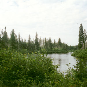
Community Description: Dense riparian shrub vegetation (>80% cover) is dominated by a mixture of red osier dogwood and shrub willows. Alders may be present but are not dominant. A band of bush-honeysuckle often forms at the upslope edge where the shrub vegetation abuts upland forest. Herb richness may be high in openings among the shrubs and may include some calciphiles as well as more widespread species. Bryoids are minor and consist of bryophytes rather than lichens. More study of alluvial shrub communities is needed. Back to top.
Soil and Site Characteristics: Sites occupy shores of larger rivers, below the annual high-water line, in areas somewhat protected from the extremes of ice scour and flooding. Riverbanks are moderate to steep, not flat; the silty to sandy soils are not constantly saturated. Successional dynamics have not been studied, but at least some sites appear to persist through disturbance. Back to top.
Diagnostics: This type is characterized by 1-3 m tall shrub vegetation with red osier dogwood and willows prominent, on riverbanks where annual disturbance creates a non-forested zone between the summer water level and adjacent forest. It occurs mostly on larger rivers and on soils that are not regularly saturated. Back to top.
Similar Types: Related to and sometimes contiguous with other rivershore communities. Tall Grass Meadows are strongly dominated by bluejoint and occur on flatter substrates. Riverside Seeps have more sweetgale and sedges, often have seepage waters at the surface, and have indicators such as grass-of-parnassus and yellow sedge. Laurentian River Beaches are dominated by herbs and low shrubs. Back to top.
Conservation, Wildlife and Management Considerations: Natural river hydrology, with annual fluctuations, is important in the maintenance of this community. These areas receive little direct use but may be affected by adjacent land use, so an intact buffer of adjoining upland would be helpful. No studies of the dynamics of this community have been done.
These rivershore shrublands provide habitat for common bird species that inhabit open shrublands such as common yellowthroat, alder flycatcher, Wilson’s warbler, and Lincoln’s sparrow. Wood turtles may also use this riparian habitat. Back to top.
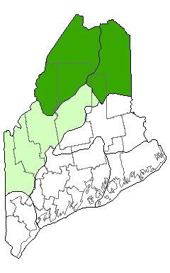
Distribution: Documented from northern Maine along the St. John and Allagash rivers, and may occur on other fairly large rivers in northern Maine (Laurentian Mixed Forest Province and New England - Adirondack Province). Presumably extends into Quebec and New Brunswick. Landscape Pattern: Small Patch, linear. Back to top.


Characteristic Plants: These plants are frequently found in this community type. Those with an asterisk are often diagnostic of this community.
- Sapling/shrub
- Bush-honeysuckle*
- Red osier dogwood*
- Red-tipped willow*
- Round-leaved dogwood
- Shining willow
- Speckled alder
- Herb
- Bluejoint
- Flat-topped white aster
- Fringed bromegrass
- Fringed loosestrife
- Spotted joe-pye weed
- Auricled twayblade
- Blue-leaf willow
- Furbish's lousewort
- Nantucket shadbush
- Northern painted-cup
- Sandbar willow
There are no documented rare animals associated with this natural community.
Examples on Conservation Lands You Can Visit
| Example | County |
|---|---|
| The Nature Conservancy's St. John River Lands | Aroostook Co. |