DACF Home → Bureaus & Programs → Maine Geological Survey → Explore Maine Geology → Bedrock Geology → Geologic History → Figure 2
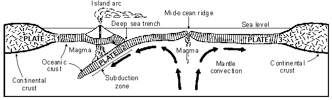
Figure 2. Schematic cross section of the Earth's crust and upper mantle, showing three large plates in relative motion. New oceanic crust is generated at a mid-ocean ridge along the divergent boundary between plates 2 and 3. A volcanic island arc is forming on plate 1 above a subduction zone along the convergent boundary between plates 1 and 2.
Last updated on October 6, 2005